Glentanassig Forest Park.
Distance:- 8.5 km
Time 2 hours
Start:- Forest Car Park
Finish:- Forest Car Parks
Nearest Village:-Castlegregory.
Map: OSI Discovery Series. Sheet
Click on this lnk for google maps directions.
https://www.google.ie/maps/dir/Castlegregory,+Martramane,+Co.+Kerry/Glanteenassig+Forest+Park,+Glanteenassig,+County+Kerry/@52.2291618,-10.0655404,6781m/
(Car parking is available. Roads are quite rural and narrow so caution is advised.)
and click on this link for an outline of the walk itself :- https://www.plotaroute.com/route/969835
or https://www.activeme.ie/guides/glanteenassig-including-lough-caum-loop
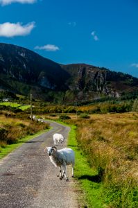
 A short drive of 18 minutes and 8km from Castlegregory will bring you this stunning location. As you enter the Park there are two car parks one at the start and the second up at the top. You may walk from the first Car park all the way up to the second if you are energetic and have the time otherwise drive but then what about the experience. The first opportunity to experience the beauty of the Glanteenassig Loop Walk is about 1.2 km from the car park. Just after crossing a wooden bridge, take a left along the trail to the shore of Lough Slat. This quiet lake lies below dramatic cliffs of Carrigaspanaig. This scene can be even more dramatic after heavy rain when “a thousand wild fountains rush down to that lake from their home in the mountains.” (J.J. Callinan). It is easy to understand the origin of the name Glanteenassig or Gleann Ti an Easaigh which translates to the Valley of the Waterfalls. Glanteenassig Woods & Lough Caum is a easy to moderate 2 hour walking route on paths through the woods plus a great scenic loop of Lough Caum on mostly boardwalks to protect the delicate terrain.