Stradbally, Beenoskee, Beenatoor, Coombane.
Distance :-13.6km
Time hours depending on route:- 4hrs
Start:- Start at Q60559 12097,
Finish:– Q56499 11623 4.1km West from Start.
Ascent:- 960m
Nearest Village:-Castlegregory/Stradbally
Map: OSI Discovery Series. Sheet 70
Click on this link for google maps directions.
https://www.google.ie/maps/dir/Tailors+Row,+Co.+Kerry/52.243817,-10.0420406/@52.248867,-10.0432697,3389m
(Car parking is very limited at the entrance to the forestry.)
Courtsey of https://mountainviews.ie/track/3158
4-5 minute drive from Castlegregory this is a clockwise horseshoe route (best to have two cars to avoid adding an extra 4k of tarmac trudging) taking in Stradbally, Beenoskee, Beenatoor & Coombane. We did this route on a day where the mist was coming and going, but even so we were rewarded with fantastic views when it cleared. I can only imagine that it must be spectacular on a clear day. The diamond in the rough is Coombane – tempting not to bother to trek out to it but so rewarding if you do!
From the Start to Stradbally
The start point is about a 25 minute drive from Tralee along the coast road towards Castlegregory and passing through Blennerville along the way. About 2km after the turn-off for Castlegregory, there is a forest entrance on the left directly opposite a t-junction at Q6055 1209. You can park here and follow the gentle rising gravel path as it winds through the forest (after approx. 1.2km, keep left at the junction) . After 3km, the road comes to an end at a pair of telecom masts. Cross the gate here and turn south, keeping the wire fence on your left as the gradient gets a bit steeper. Following the fenceline towards the ridge. Lough Gill & Castlegregory below.
When the fence comes to an end, continue in a southerly direction in order to gain the ridge towards the summit. There may be a little bit of scrambling required in the last stretch to the ridge. Follow the gently rising ridge, keeping the fence line on your left) to the summit of Stradbally mountain, where the views down to Lough Acummeen and across to Beenoskee open up nicely. View from Stradbally looking west to Beenoskee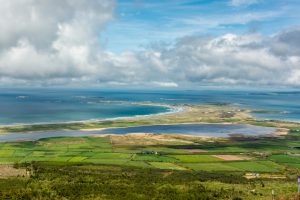
Dropping into the col, it’s a short 1km hop across to the cairn at the summit of Beenoskee, the half-way point and the highest point of the walk. The initial descent from Beenoskee (head southwest to avoid the steepest ground on the northern side) is steep with loose rocks underfoot at times, before changing to flatter and wetter ground at the bottom with a nice mixture of peat hags and bog holes to hone your bog jumping technique. At the base of the col, swing back in a north-westerly direction to skirt around the base of Coombane on the way to Beenatoor.
Trekking towards Beenatoor with Coombane in the background
While the summit of Beenatoor is relatively flat and unremarkable, the out and back detour (adds about 2km to route) is well worth it for the view down into the steep sided Glenahoo valley directly below and further afield to the Brandon ridge.
From the summit of Beenatoor, retrace your steps to the bottom of the col before veering uphill to the northwest until meeting a fence which can be followed eastwards almost to the summit before again turning northeast to reach the highest point.
There is a steep drop to the north of the summit, so take care to locate the ridge (quite a well defined grassy track) running northeast and descend (keeping the steep drop on your left) until it is possible to drop off the ridge and into the valley below to the north. You will need to cross a small stream, before picking up the pathway (initially grassy, the becoming more stony) which leads back to the road at Q5649 1162 . Ideally, have a second car here to avoid a 4km trek back along the road to the start point.
Trackback: https://mountainviews.ie/track/3158