Maghanabo & Glennahoo Valley Loop Walk
Click on this link for google maps and directions from Castlegregory to Start of Walk.
www.google.ie/maps/dir/Tailors+Row,+Co.+Kerry/Macha+na+Bó,+Co.+Kerry/@52.2149595,-10.1052031,13914m
(Car parking is very limited. Roads are quite rural and narrow so caution is advised.)
and click on this link for an outline of the walk itself :- https://www.plotaroute.com/route/969847
Click on this link for google maps directions for an alternative walk.
http://www.activeme.ie/guides/maghanabo-loop-walking-route/
Distance :-10km
Time 4.5 hours depending on route.
Maps:- OSI Discovery Series 70
Start:- Glennahoo, Scraggane, Co. Kerry 52.226487, -10.128891
Finish:-Glennahoo, Scraggane, Co. Kerry 52.226487,-10.128891
Ascent: 474m
Nearest Services: Coghane /Stradbally.
Car Parking: No-find suitable spot without obstructing anybody.
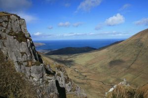
14 minute or 10 km drive from Castlegregory will set up for the Machanabo and Glennahoo River Valley Loop Walk, It is a strenuous 4.5 hour (10 km) walking route with a great ridge walk to Beenbo Mountain (474m) and back through the picturesque Glennahoo River valley west of Tralee, county Kerry in the south west of Ireland. This walk is only a short drive from Tralee. If you are willing upon reaching the summit you could cross over and decent into Annascaul Lake but the you would need a second car or a pick up arranged. Very achievable with great views on both side.